2,500 Ft (Length) x 36 Ft (Width) Chip-Seal Asphalt
Elevation:
55 Feet AMSL
Runway Orientation Numbers:
10/28
Type:
Public, Non-Towered
Visual Aids:
Windsock
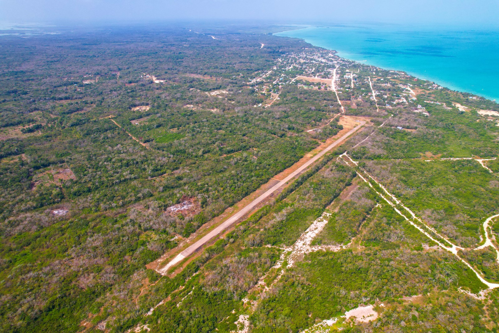
Sartaneja Airstrip in Sartaneja Village, Corozal District is a public Aerodrome owned and managed by the Belize Airports on behalf of the people and Government of Belize. The aerodrome is licensed for air operations.
OPERATIONS AT SARTANEJA AIRSTRIP IN SARTANEJA VILLAGE, COROZAL DISTRICT.
A. Introduction
Sartaneja Airstrip in Sartaneja Village, Corozal District and is open to aircraft operations. Certain operating limitations are in effect, and these are detailed below. Sartaneja Airstrip is not an international port of entry or departure and as such, all international aircraft operations must enter and depart via the Philip S. W. Goldson International Airport. Caution must be exercised whilst operating at this Airstrip.
B. The following are some particulars of this Airport:
Distance from the P.S.W.G. Int´l Airport: 49.8NM North
Surface:
a) Parking Areas/Apron – Chip-Seal Asphalt
b) Runway – Chip-Seal Asphalt
c) Taxiway – Chip-Seal Asphalt
Runway Length: 2,500 feet
Runway Width: 36 feet
Runway Orientation Numbers: 10/28
Aerodrome Reference Code: 1A
Runway Strip: 85 feet to the North and 100 feet to the South of the runway. Stopway east of THS 28 is 200 feet and stopway west of THS of 10 is 200 feet.
Obstacles: Windsock located 90 feet from runway center.
Type of operation: Non-instrument aerodrome and is to be used only in Visual Meteorological Conditions.
Night operations: No Runway lights available. Not certified for night operations.
Air traffic density: Light
Facilities: No navigational aid or Air Traffic Control Services.
Other Information: Caution whilst operating here. Aerodrome close to the Chetumal Int’l Airport Mexico, which is 13.5 NM West North-west of SJX.
Declared distances:
Runway – 10
Take – Off Distance Available (TODA) – 2,650 FT.
Take – Off Run Available (TORA) – 2,500 FT.
Acceleration Stop Distance Available (ASDA) – 2,650 FT.
Landing Distance Available (LDA) – 2,500 FT.
Runway – 28
Take – Off Distance Available (TODA) – 2,700 FT.
Take – Off Run Available (TORA) – 2,500 FT.
Acceleration Stop Distance Available (ASDA) – 2,700 FT.
Landing Distance Available (LDA) – 2,500 FT.
C. Operating Limitations:
Foreign aircraft desiring to operate at the Sartaneja Airstrip must first satisfy the entry requirements from the facilitation agencies at the Philip S. W. Goldson International Airport. Aircraft must subsequently obtain a written approval from the BAA. AIS/ARO, Department of Civil Aviation will confirm BAA’s authorization to conduct domestic flying at the SJX prior to the aircraft’s departure from the Philip S. W. Goldson International Airport.
Only those aircraft whose Maximum Take-Off Weight (MTOW) which does not exceed 12,500 pounds are allowed to operate at the Sartaneja Airstrip subject to prior approval as described in (a) above.
Jet engine aircraft shall not be allowed to operate at this aerodrome due to the limited runway/taxiway PCN and the noise factor
Helicopters are allowed to operate at this aerodrome however these will require approval of the Belize Airports Authority. Requests are treated on an individual basis.
D. Conclusion
Further information and pre-flight briefings are available at the AIS/ARO located in the Terminal Building’s First Floor, Philip S. W. Goldson International Airport.